Sunday, 28 September 2014

Corjuem Fort: Have You Been Here?

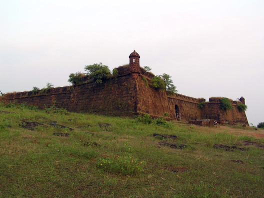
Situated at a distance of 4 kilometers from the village of Aldona. On the Island of Corjuem is an old Portuguese fort known as the Corjuem fort. The fort was built in 1705 and is one of the only two inland forts that are surviving made of pitted laterite. In the eighteenth century this fort protected the Portuguese from the Marathas, Bhonsles and the Rane Rajputs. The fort also has an interesting story according to which an ambitious Portuguese woman named Ursula e Lancastre landed up here as a soldier as she was determined to succeed in a man's world and also dressed like one. The earlier chapel of St Anthony was known to have been in the Corjuem Fort.


It is smaller compared to the other forts in Goa. But it gives a good view of the surrounding river and land. It was more like a solitary outpost. The walls are wide and have numerous gun ports and murder holes. At each corner of the fort is a ramp like stair that leads to the ramparts. The fort has a well and a three room living quarters. Within the fort is also located a small chapel which seems to be a relatively new addition. The fort is surrounded by lush greenery and one can get a full view of beautiful villages and islands nearby. Corjuem is well connected with Aldona by a cable suspension bridge which is a major source of attraction as it is the only suspension bridge in Goa.

Anjediva fort

About the island :-Anjediv—the name means "fifth island" is the largest of an archipelago of five islands (known as the Panchdiva chain of five islands); the other four islands are the Kurnagal, the Mudlingud, the  Devgad and the Devragad. The fort island was also known as Agiadvipa (clear butter), Angedvpa (some isles), Agadvipa (derivative from goddess Aja ) and Adiadvipa (Ancient Island). It was called Aigidias by the Greek geographer Ptolomey.Etymology of Anjediv is also attributed to the name of the local Goddess Ajadurga Devi.

The fort :-It was initially developed for enhancing the military power as well as for overseeing the naval trade and business. The fort is small in size and the architecture exposed by excavations demonstrate that Anjediva Fort has large pillars along with various stone works and pots. The architecture of Anjediva Fort is based on the work of Kadambas and Chalukyas dynasty who ruled during the period of 11th and 12th century respectively. Anjediva Fort houses a church namely, 'Church of Our Lady of Springs' which was supposed be the temple of Aryadurga in traditional times. However, in later days the temple was converted into a church. The fort and the church both were situated in Anjadip Island with an area of about 1.5 square kilometre.

Its history :- In the year 1505, a Portuguese ruler, named Dom Francisco appeared in India and ordered to create four forts and one of them is Anjediva Fort. The fort was intended to act as vital hub for trade, mainly spices in several nations. In order to enhance the trade and to obtain better managerial control in Goa, a famous mariner Vasco da Gama along with a Jewish seller, Gaspar da Gama demanded the then Portuguese ruler to develop a maritime fort in the region of Anjediva. As a result, Dom Francisco initiated the construction of Anjediva Fort in 1505. The local people provided the requisite materials such as timber and bamboo among other stuffs in order to create the fort. It is said that the temple of Aryadurga which was situated in that area was used in order to gather stones for the construction of Anjediva Fort. It took approximately three months in order to create the fort.
After some year's Dom Francisco demolished the fort and its crumbling rooms are still viewable in present days.
In 1682, another Portuguese ruler named Alvor had reconstructed Anjediva Fort with inhabitation of over 600 persons. Facilities such as school and college was also established in the fort. Nevertheless, Anjediva Fort was abandoned by Portuguese people during 1843. Afterwards, Hindu and Christians started to use the fort as accommodation. It was said that when Anjediva Fort was under the authority of Portuguese rulers, it was attacked by Mughal ruler, Tippu Sultan. In the year 1961, Anjediva Fort was legitimately acknowledged as a portion of India.

Reason for building it :-it was engaged by Portuguese for military defences and also for regular naval stops for the ships and containers. The fort permitted Portuguese rulers to overthrow various strong foes. In the year 1506,

Wednesday, 24 September 2014

Tiracol fort

entrance to the Tiracol fort
A friend’s father was narrating his discovery of absolutely inexpensive yet amazing  accommodation in the Northern tip of Goa in no less than a beautiful fort-Tiracol. His visit was in the 1980’s.
Being intrigued, a little research revealed that this fort is situated at the mouth of the scenic Tiracol river and bordering Maharashtra.Just 42km north of Panaji, the quaint ferry ride from Querim makes the beginning of this journey an enjoyable experience.
The strategic location of the Tiracol fort was probably a well thought out plan of the original occupiers; the Raja of Sawantwadi, all this in the 17th century.
Known as Khem Sawant Bhonsle this Maharaja chose a steep hillock tobuild the fort and allow a commanding view of the Arabian sea and also watch over his fleet that used to be sheltered upstream of the River Tiracol.
The fort was well fortified with 12 guns (cannons) and had barracks within the massive walls.It was learnt that in the year 1746 the Portuguese Conte de Assumar named Marquis de Alorna defeated the maharaja after a bloody and violent seafaring war. The Portuguese maritime superiority was declared when Tiracol fort finally surrendered on 23rd November 1746.
chapel in the Tiracol fort
It was thereafter that the Portuguese marked the fort with a chapel or church constructed and dedicated to the Holy Trinity. It was later dedicated to St. Anthony/St. Andrew, which serviced the converts with all their religious solemnities
The elders who were mainly agriculturists and fisher folk talk proudly of this edifice serving as a symbolic location where freedom fighters demonstrated from time to time against the Portuguese
.On August 15 1954, Sathyagrahis who entered Goa from the north,  used the fort as a bastion of freedom and flew the Indian flag for a day before they were captured and imprisoned.
lovely view from the Tiracol fort
The walls of Tiracol fort have stories to tell. A lesser know one is that during the little known Portuguese civil war the fort served as a rebel stronghold during an uprising in 1825 against the Portuguese. Dr. Bernardo Peres da Silva the very first Goan born Viceroy of Goa led the revolt which was brutally stamped out by the commandant “TIGER KILLER” Da Cunha who entered the fort, defeated the rebel and ordered the beheading of the entire group and the staking of their heads for public display on the ramparts .  
The fort in recent years has been rebuilt and restored and maintained in an exotic way but is an expensive Heritage Holiday Luxury Getaway now unlike when my friends father visited in the eighties!!
The serenity and blissful natural beauty of the Arabian Sea and these northern coasts belie the bloody and aggressive stories of the past, but the Martyrs memorial tells one the story that for every beautiful present lies a damned and violent past.


Tuesday, 23 September 2014

Chapora Fort

There are many forts in Goa. Most of the tourist like to visit for the forts, beaches, etc. I would like to take da Chapora fort which is 10 km from Mapusa. It was build by the Adil Shaha of Bijapur on the southern headland of the Chapora river. The red-laterite bastion, crowning the rock bluff was re-built by the Portuguese in 1617 on the same site. The Chapora fort has another name Shahapura (town of Shaha's) was intended as a border watch post to see various Hindu raiders during the 17th century. 

It was finally deserted by the portuguese in 1892, after the territory's frontiers had been forced further north and novas conquistas region. The Chapora fort has a commanding view of the Vagator beach and is near to Anjuna beach. Across the Chapora river, the Hindu ruler of Pernem, the Maharaja of Sawantwadi who was an old enemy of the Portugese held the fort for two years after it felt to Maratha's. Inside the fort the church once dedicated to St. Anthony, had disappeared and inside only a few signs exist of the barraks and housing that once filled this vast area.

Once neglected, the fort was popularized by the movie Dil Chahta Hai and is now a prime attraction of Goa. Trekking up to the fort can be sternuous during the days, but its a great place to make your evening memorable. A silent stroll and pictures sunset view are wonderful. It is the best place to capture perfect shots, Vagator beach, Morjim beach, or the Arabian sea,, you will never get tired of clicking there! It is a perfect place to hangout with best of your companies or to spend a peaceful, time alone.

Sunday, 21 September 2014

Cabo De Rama Fort

Cabo de Rama fort 
Ive heard of many forts in Goa and visited some from the north. The Tiracol fort ,the Aguada fort , the Vagator fort, the Vasco Headland fort, now nearly unrecognizable! And then deep south, in Cancona -the  largest (at least to my mind) fort; named CABO DE RAMA.
It lies on the west coast of Goa, 25kms from Margao, and while all the other forts have no linkage  to Indian-ness. The very name "Cabo De Rama", raises a question as to the origin of that name. Well yes, a superficial research says that the fort was also known as Cape Rama and was the refuge and abode of Lord Rama and his wife Sita for 14 years of his exile, which , makes this fort an ancient one.
The Hindu rulers who annexed their empire were supposedly the very first occupants of the fort and  their occupancy changed  due to long and bloody battles between them, Muslim leaders and then the Portuguese who were the last occupants.  The Portuguese established their powerhouse of the deep south Goa , here, around 1763,  that protected both the land and sea routes strongly, but  they later abandoned this fort for a period of time until it was decided to house a Government prision  here till 1955.
The forts great walls though crumbling on the northern, southen and western sides are testimony  to the massive  strenght  of structure.  A deep moat runs  around  these ramparts thats made approach /crossing difficult and hazardous.

cannons  of the Cabo de Rama fort 
 The westwall boasts of a massive door with gun turrets  and cannons guarding the  entrance. This rampart on both sides of this door are stil standing tall and approximately 5-7 meters wide, tales are told that there are/were  secret getaway paths within these walls!
The great door must have been serviced with a draw bridge  but now has a permanant wooden bridge . Apparently in the old days the entire village was housed within these strong walls along with the military barracks and vestiges  of old structures still remain, the structure that's in excellent condition upto date is the "Copela de Santa Antonio"that we learnt was attached to the commandants quaters of the Portuguese.
Copela de Santa Antonio
Nowadays the village has grown outside the forts walls but all the devotees still use  this Chapel.
The northwest and southwest portion of the fort ends in craggy beach with lots of the massive fort stone walls having rolled down  in those years  of ingenuity the occupiers had great big  tanks for water harvesting and quiet a few wells strategically located and despite its proximity  to the sea  the water did not taste so brackish.
Its hard to go around the entire fort due to an overgrowth of shrubs and bush but when one does find a way to see both the northern and southern sides, the picture of blue green Arabian sea meeting a blue cloud spotted sky with a waywerd breeze whistling through the palms is ironically peaceful and tranquil for such a violent historic site .
a view from the fort 
The beaches around the area are virgin white with a few rocky outcrops and wonderful for fishing the villagers here are a typically Goan hospitable and pleasant lot and love to share intreating tales of the ghosts of the fort .

Reis Magos Fort

Reis Magos is located on the northern bank of the Mandovi River.
It was built in the year 1551.The Reis Magos Fort is situated a little above
an old outpost. It had a defensive system capable of curbing the
crossing of enemy ships through the Mandovi waters. The
high walls are topped at vantage points by cylindrical watch
turrets,a distinctive feature of medieval fortifications. The
fort had the advantage of a perennial source of water from a
nearby spring.It is now owned by the Government of Goa 
and listed under the Goa Ancient Monuments and Archaeological Sites 
and Remains Act, and is the oldest fort in Goa.


It has now been renovated beautifully. Old pictures and paintings of Goa have
been put up. The view of mandovi river and the Panaji city on the
other side of the river makes this place a must visit.
Due to the strategic importance of Reis Magos fort extensive
changes to the structure were carried out in the year 1707
during the administration of Caetano de Mello e Castro and
was defended by 33 guns of different calibre.
The Reis Magos Fort was converted to a sub-jail to lodge
short term convicts; it was also used to lodge some of the
freedom fighters working for the liberation of Goa when the
movement intensified in the 1950's. The fort functioned as a
jail till 1993 and during this period a number of modifications
were carried out. Once abandoned the fort fell into decay.

From 5th June 2012 the fort was made open for public to
enjoy a glimpse of Goa's past and her heritage.

Aguada fort

It is a tourist spot many tourist visit it. It is a beautiful place and it is said to be a haunted place so by 5:30 it gets closed down.
This is the largest and the best preserved Portuguese bastion in goa and was built in 1612, to control the entry into the river Mandovi and to protect old goa from potential enemy attacks.
A fresh water spring-from where the fort derives its name-with in the fort provided water supply to the ships that called there Ring by thick battlements strategically located at the estuary of the river Mandovi, this fort was constructed in 1612 as a guard against invasions from the Dutch and Marathas.
The walls of this fort are 5 metre high and 1.3 metres wide little surprise then that this remains to be the only fort that was not conquered by any invaders during the 450 years long rule of the Portuguese empire .
The area around the fort housed a large well and a number of spring that provided fresh drinking water to the voyagers that arrived by ship 'Aqua' in Portuguese mean water , thus the fort derived its name "Aquada" to denote a place where water is accumulated.